


When Jarrett Lash took on the role of Township Planner for Upper Merion Township, home to the famed King of Prussia Mall and the county’s largest office park, he quickly realized he’d need to do more with less. As a planning team of one, Jarrett carries the responsibility of shaping the future of a community with nearly 65,000 daily employees, only 38,000 residents, and virtually no undeveloped land left.
The township’s mission is clear: make fiscally sound, forward-looking decisions that preserve services, strengthen the tax base, and improve quality of life. But those decisions depend on something many cities struggle with—understanding what zoning actually builds.
I’m a planning team of one, so I need force multipliers. What used to take a day in SketchUp, I can now do in 15 minutes live with elected officials in public meetings to show them the changes in real time.
From Vision to Visualization
Upper Merion has long been a regional powerhouse: just 3.58% of the county’s land area, yet home to 18.2% of its office park, 15.4% of its retail, and 10.4% of its large apartment buildings with 10+ units. But post-pandemic tax appeals from commercial offices and aging infrastructure have forced the township to rethink its growth model. Jarret believes that the next 30 years will hinge on mixed-use redevelopment, new housing supply, and smart fiscal stewardship.
That’s where TestFit enters the picture. Instead of relying on static sketches or outside consultants, Jarrett uses TestFit site planning AI to generate real-time, buildable models that reveal what zoning decisions mean for density, traffic, stormwater, and fiscal outcomes—all before a text amendment is passed.
We’ll hear ‘this won’t pencil.’ With TestFit, we can gut‑check: our run looks viable. It keeps policy tied to what can actually be financed and built.
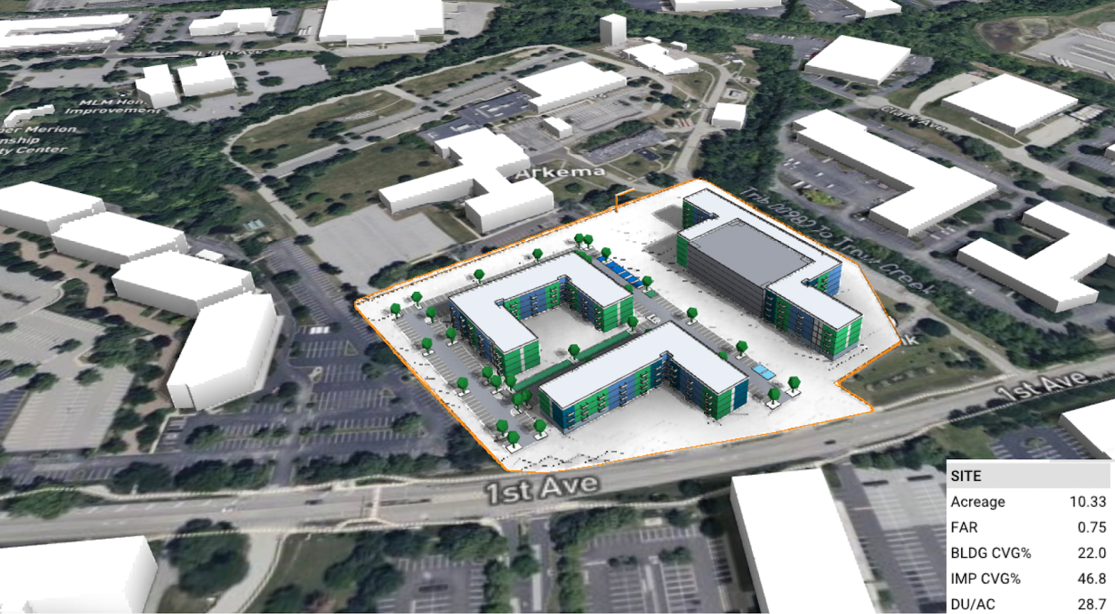
Use Case 1: 45 DU/acre vs. 30 DU/acre
One of Jarrett’s early experiments with TestFit involved a 10-acre parcel subdivided for redevelopment. It had been a simple grassy lot with a few aging office buildings, but planners saw potential for new multi-family housing. The question: what density makes sense?
- 45 dwelling units per acre (a former density standard)
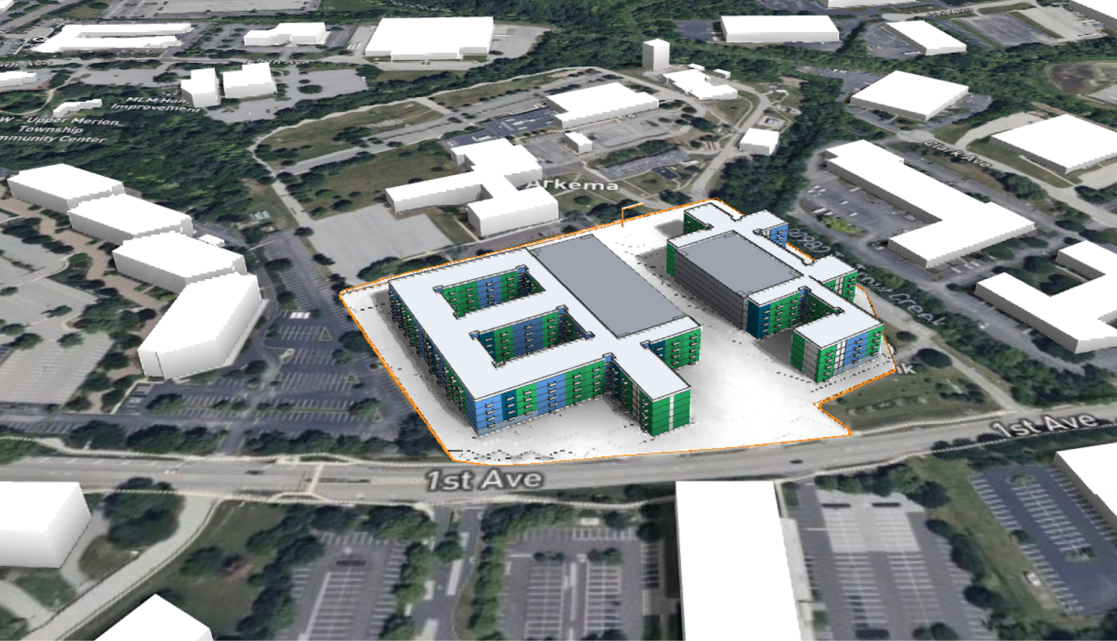
- Or 30 dwelling units per acre (the current density standard)
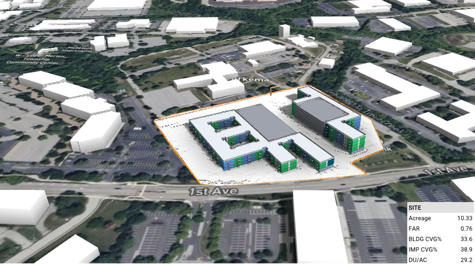
In a matter of minutes, Jarrett drew in access roads, applied setbacks, and generated both options live. The visual difference was modest, but the fiscal and environmental differences were profound.
The exercise became a teaching tool for elected officials and residents alike, showing that policy tweaks aren’t abstract; they reshape the skyline and the tax base.
Use Case 2: Reducing Impervious Coverage by 20%
Upper Merion sits at the base of the Schuylkill River watershed, making stormwater management a long‑term cost driver for the township. Using TestFit, Jarrett quickly demonstrated how shifting from surface parking to structured parking could reduce impervious coverage from 47% to 38%—a nearly 20% improvement that preserved housing yield while creating more green space.
Being able to visualize these trade-offs helped reframe stormwater from a burdensome requirement into a design strategy. While structured parking costs more, often 5× per stall, the environmental and fiscal benefits became clear when shown side by side. TestFit made it easy for Jarrett to explain why zoning incentives such as reduced parking minimums or density bonuses may be necessary to support these better outcomes.
By condensing complex engineering, financial, and design considerations into a simple visual comparison, TestFit turned stormwater planning into an integral and achievable part of zoning policy.
Use Case 3: Redeveloping 85% of Underutilized Parking Lots
Upper Merion’s retail corridors thrive, but they’re also paved with excess. A recent parking study revealed that even during peak hours, big-box lots were only 7–15% occupied. Using TestFit, Jarrett illustrated what could happen if the township reclaimed 85% of these underutilized parking lots for redevelopment.
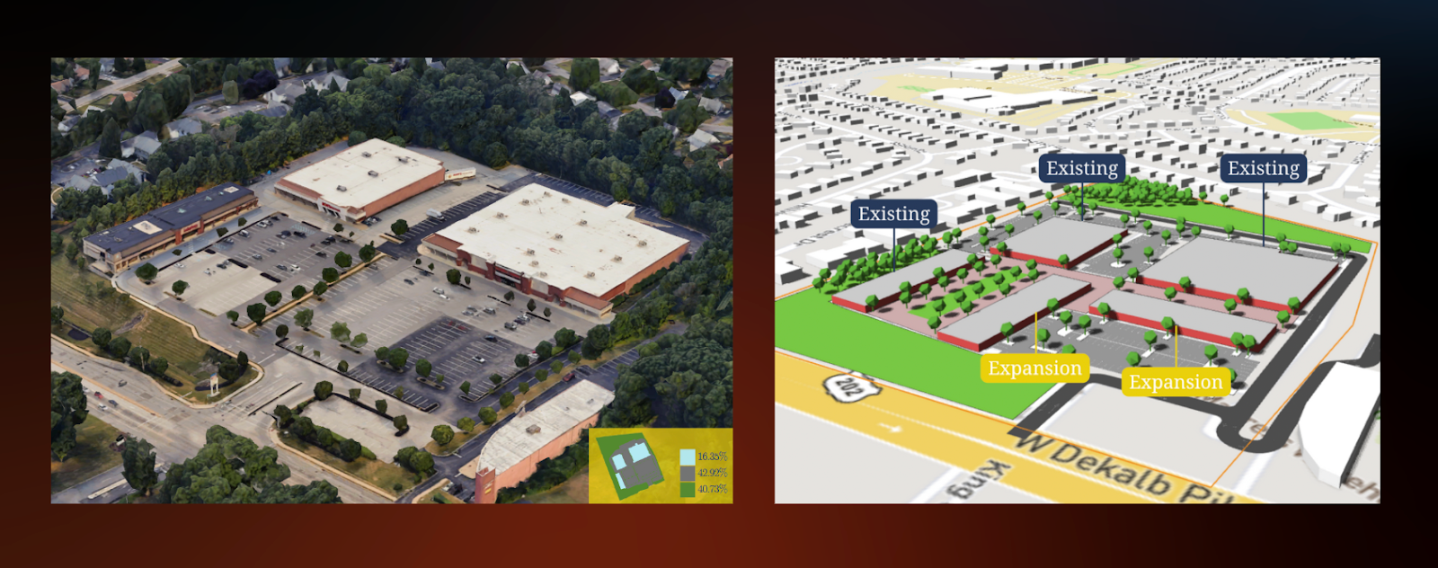
Within minutes, he transformed acres of asphalt into a tree-lined main street, complete with cafes, walkable plazas, and infill retail. It wasn’t just an aesthetic upgrade; it was a new vision for how tax revenue, housing opportunities, and public space could coexist on the same footprint.
We’re leaving a lot on the table, tax revenue, jobs, housing, when parcels are locked up in parking that no one’s using.
Of course, lease constraints and property rights make change complex. But showing what’s possible helps residents and developers alike imagine a different future. It reframes the conversation from “Why change?” to “Why not?”
Use Case 4: Building Walkability into Setback Policy
For more than a decade, Upper Merion’s Business Improvement District has been knitting together its office parks with the First Avenue Linear Park—a multimodal greenway connecting major employers. Today, the Township requires a 25-foot common area easement on new developments to extend that connectivity parcel by parcel.
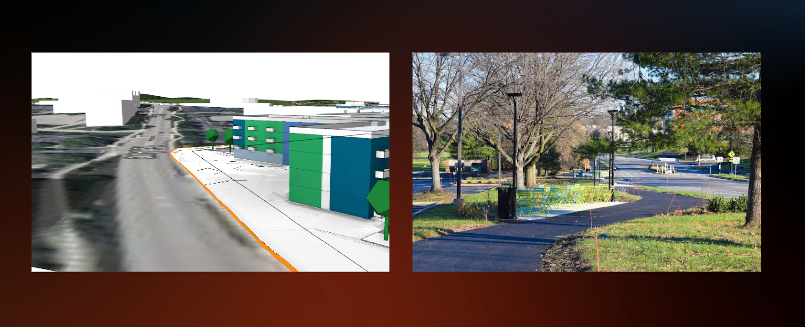
Using TestFit, Jarrett can quickly visualize setbacks and frontages to ensure new projects contribute to that network. By pulling buildings closer to the street and swapping front-lot parking for pedestrian space, the Township can bring ground-floor retail and walkability to areas once dominated by cars.
We don’t want people walking through two parking lots just to reach the park. We’re using TestFit to make sure our setbacks actually build the streetscape we envision.
The Fiscal Feedback Loop for the Next 30 Years
Every zoning amendment is a fiscal decision. By pairing TestFit’s cost estimates with Upper Merion’s local assessment data, Jarrett can model how a proposed project might affect long-term revenue and service costs. The township can then identify which forms of development strengthen its operating position.
We’re stewards of the tax base. Tying form to fiscal lets us say, this zoning will pay for the lights, roads, and public safety for the next 30 years.
This holistic approach makes zoning a proactive instrument, not a reactive one. It connects the dots between form, finance, and feasibility in ways that resonate with residents, boards, and developers alike.
A New Model for Modern City Planning
For Jarrett, TestFit isn’t just a tool—it’s a bridge between policy and possibility. It enables city planners like him to test ideas in real time, demystify zoning for residents, and back decisions with data. Most importantly, it helps a small municipal team plan at the scale of a city ten times its size.
Policy should reflect the reality of getting things built. TestFit helps us meet in the middle between what we want for our communities and what pencils for developments.
Upper Merion Township’s planning process has become a model of clarity and collaboration where zoning isn’t written in the abstract, but drawn, tested, and proven before it ever hits the books.

